


Sunday, September 8th, 2013
How The Rampal Coal Power Plant Will Destroy The Sundarbans
Land acquisition order to setup a 1320 MW coal based thermal power plant in Rampal near Sudarbans, the largest Mangrove Forest of the world and a world heritage site declared by UNSECO, was issued on 27 December 2010. The Joint venture agreement to set up the power plant was signed between Indian company NTPC and Bangladeshi company PDB on 29 January 2012. And the EIA was published on January 2013 in the PDB website for public opinion. That means EIA has been done after selecting and finalizing the site where as the very purpose of any EIA is to select a site among many alternatives and decides whether the project on that site is environmentally viable or not. The experts and various organizations present in a people’s consultation arranged by PDB on April 2013, has already rejected the EIA, the department of environment has not approved the EIA yet but the governments of Bangladesh and India are still continuing the project, currently land filling activities is going on which is being implemented by Bangladesh Diesel Plant(BDP), a subsidiary of Bangladesh Army.
As coal based power plant creates serious environmental pollution, no country in the world usually gives permission to set up large coal based power plant within 20 to 25 km distance of forest, agricultural land and residential area. The distance of the proposed Rampal coal based power plant from the Sundarbans mangrove forest is just 14 km, which, the EIA claims as a safe distance. But the very NTPC company which will build this coal based power plant within 14 km of Sundarbans, would not be able to do this in its own country India because the EIA guideline manual for coal based thermal power plants prepared by Indian Ministry of environment and forest in August 2010, clearly states that:
“Locations of thermal power stations are avoided within 25 km of the outer periphery of the following:
– metropolitan cities;
– National park and wildlife sanctuaries;
– Ecologically sensitive areas like tropical forest, biosphere reserve, important lake and coastal areas rich in coral formation;”
But in Bangladesh, it is being allowed to set up a large coal based thermal power plant at a distance of 14 km. Some experts are even in opinion that the distance is not more than 9km. The EIA itself also acknowledges that: “Once it was a part of Sundarbans but had been evacuated by the settlers.”
 Image
Image
So, whatever the actual distance is, the area which was once part of the Sundarbans is still closely linked with the Sundarbans through networks of rivers and canals. So, any environmental degradation of this area caused by the coal power plant will surely spread to the Sundarbans region. That’s why it is utmost important to analyze the potential environmental impact before setting up the 1320 MW large coal based thermal power plant.
Impacts during pre-construction and construction stages:
It will take four and half years to complete the 1320 MW (660X2 ) coal based thermal power plant. The impact during this pre construction and construction phase are as follows:
1. For the proposed Rampal Coal Power Project, 1834 acres of land has been acquired by the government forcefully which is mostly agricultural and shrimp aquaculture pond (gher). The EIA states that: “The land use of the area is dominated by shrimp aquaculture cum rice cultivation. In general, this agricultural land covers 75% of the study area and 95% of the project area.”(Rampal EIA, Page 135). According to the EIA report, agriculture and aquaculture production from the Project & Study Area are as follows:
a) Rice production is 62,353 tons in the entire study area (project and 10 km radius from plant location) and 1285 tons in the project area.
b) The amount of non-rice crops is about 140,461 tons in the study area.
c) The livestock and poultry population per households in the project and study area has been estimated to comprise of 4 and 3 cattle, 3 and 2 buffaloes, 4 and 4 goats, 1 and 1 sheep, 5 and 5 duck and 7 and 6 chicken respectively.
d) The fisheries resources of the study area are rich and diversified with mainly brackish water to minor fresh water fish habitats. The area has a close connection with mangrove forest providing support to a number of marine and fresh water fishes. The network of river systems of this region connects the fresh water fish habitats with the brackish water habitats and maintains biological balance of the major fish groups.(Page 198)
The estimated total fish production of the study area is about 5218.66 M.ton, which comes from both capture fisheries (565.66 M. ton) and culture fisheries (4653. M.ton). On the other hand, the estimated total fish production from the project area (project boundary) is about 569.41 M.ton (capture 4.79 M.ton & culture 564.62 M.ton).(Page 204)
The EIA acknowledge the losses of these : “Acquired land includes shrimp aquaculture farm, mangrove, intertidal area, and tidal creeks which are used as, fish habitat. Acquisition of these lands might cause loss of these habitats.… Construction work including land filling by dredging, sand lifting, site clearance and physical construction of plant setup etc. which may have impacts on open water fish habitats, fish diversity and hence to some extent on capture fisheries production… Open water fisheries habitats like rivers (Passur, Maidara), khals and inter-tidal area may be affected due to dredging, traffic movements, and oil and chemical spilling. Dredging activities may also alter the habitat of the bottom feeder fish for short period.” (Page 266)
But at the same time it also hopes that: “However, the expected benefits of the project overcome these losses.”! (Page 266)

2. As the materials and equipment would be transported by river to the project site during the construction period, the frequencies of the vessels will relatively increase. Hence the EIA report express concerns that : “If navigational, spillages, noise, speed, lighting, waste disposal rules regulations are not properly maintained, it may impact the Sundarbans ecosystem especially Royal Bengal Tiger, deer, crocodile, dolphins, mangroves etc.”
3. Some scattered mangroves would be removed for jetty construction.
4. Suspended particulate matter to be produced from construction activities will be deposited in the surrounding areas and water bodies including river and will change habitat quality of aquatic and terrestrial ecosystem.
5. During construction phase, solid waste and wastes water discharged to the river would cause water pollution.
6. Navigational activities for transporting construction materials through the Sundarbans and dredging activities would create disturbance to fish migration. During the dredging operation, fish migration would be disturbed within the dredging operation area.
7. Alteration of shrimp farming area (gher) and agricultural land for site establishment will cause loss of feeding ground and nesting habitat of different terrestrial common birds like Dove, Eagle, starling etc.
Impacts during operation stage
The coal power plant will be operational for at least 25 years. During operational phase the impacts of the power plant on Sundarbans are as follows:
Impacts of Toxic Sulfur and Nitrogen Gases:
As per the EIA, 142 tons of SO2 and 85 tons of NO2 will be emitted daily from the 1320 MW coal power plant. This will obviously increase the concentration of SO2 and NO2 in the ambient air near Sundarbans region which will destructive for whole the environment of the region. But to show that the emission is well under allowable limit under Environment Conservation Rule 1997(ECR 1997)and thus justify the coal power plant, the EIA has done a trick, it considers the Sundarbans as a ‘residential and rural area’, instead of an ‘ecologically critical area’!
The EIA report states that: “The concentration of SO2 in the ambient air near Sundarbans region is found 8 to 10 μg/m3… Hence, it is found that the resultant concentration (24 hr average after emission contribution and only during November to February) from the power plant) of SO2 in the ambient air may be maximum 53.4 μg/m3 which is much below the MOEF’s standard (ECR 1997), 80 μg/m3 for residential and rural area. Therefore, the concentration of emitted SO2 is very insignificant to have any impact on Air quality of Sundarbans.”
In the same way, it claims that although the concentration NO2 would increase threefold, from 16 μg/m3 to 51.2 μg/m3, it is still safely below the limit set by ECR 1997!
But can Sundarbans be really considered as a residential and rural area? How and why the Sundarbans, the greatest mangrove forest of the world, a Ramsar Site and UNESCO world heritage site has been considered as a residential and rural area instead of ecologically critical and sensitive area? The reason becomes clear after checking the emission standards of ECR 1997. The emission standards set for ecologically sensitive area is 30 μg/m3 both for SO2 and NO2 which is much below the resultant concentration due to coal power plant. So, if this standard of ecologically sensitive area had been chosen in the EIA, the viability of coal power plant would automatically be proved negative. That’s why the EIA chooses a safer and higher emission standard of ‘residential and rural area’ to justify the coal power plant!
In the same way, some thirty years ago in Texas, USA, the 1979 Final Environmental Impact Statement (EIS) for the new Fayette plant had also ensured that there would be no adverse impacts on the nearby pecan orchards and other vegetation. Fayette power plant had a capacity of 1230 MW at first, after few years its capacity was increased to 1690 MW. Annual emission of SO2 from this plant is 30 thousand tons. What is impact of this SO2 emission on the surrounding areas and how far this has been felt? Observations of Fayette area pecan trees indicate massive devastation and classic symptoms of acid pollution damage from airborne exposure. A cluster of orchards with 3,000 trees indicates no healthy trees and the vast majority are either dying or dead; rows of dead trees have been removed. Other orchards show a similar pattern of devastation. Pecan tree injury can be observed all around the Fayette area. Several other broad leaf tree species appear to show signs of injury. (source: http://texaspecangrowersalliance.files.wordpress.com/2010/12/fayette-power-plants-sulfur-dioxide-and-acid-pollution1.pdf)
And this impact has been observed along the 48 km stretch of Highway 21 where the plant community is just devastated. Huffington post writes: “Along a stretch of Highway 21, in Texas’ pastoral Hill Country, is a vegetative wasteland. Trees are barren, or covered in gray, dying foliage and peeling bark. Fallen, dead limbs litter the ground where pecan growers and ranchers have watched trees die slow, agonizing deaths.

Visible above the horizon is what many plant specialists, environmentalists and scientists believe to be the culprit: the Fayette Power Project — a coal-fired power plant for nearly 30 years has operated.”
(source: http://www.cleveland.com/nation/index.ssf/2010/12/farmers_pecan_growers_claim_su.html)
If annual emission of 30 thousand tons of SO2 from the Fayette power plant could destroy the vegetation of as far as 48 km, then what might be the impact of 142 tons/day or 52 thousand tons/year of SO2 emission from the Rampal coal based thermal power plant on the vegetation of the mangrove forest Sudarbans which is just 14 km away from the proposed rampal power plant?
Emission from Fayette coal power plant had destroyed Pecan, elm amd oak trees, but the destruction caused by the SO2 emission from the Rampal power will not be confined to the destruction of some mangrove trees like Sundari, Goran, Geoa, Golpata, it will have a devastating impact on the whole mangrove food web!
Mangrove food web:
Energy flow in mangrove ecosystem is as follows:
Mangrove leaf detritus – Bacteria and fungi – Detritus consumers (herbivores and omnivores) – Lower carnivores – Higher carnivores.
The chain begins with the production of carbohydrates and carbon by plants through photosynthesis. Leaf litter is then fragmented by the grazing action of amphipods and crabs. Decomposition continues through microbial and fungal decay of leaf detritus and use and reuse of detrital particles (in the form of faecal material) by a variety of detritivores, beginning with very small sized invertebrates and ending with such species as worms, molluscs, prawns and crabs, who in turn are preyed upon by lower carnivores. The food chain ends with higher carnivores such as large fish, birds of prey, wild cats or man himself.
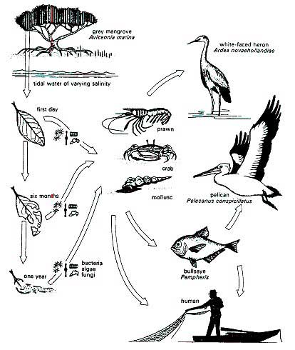
Source: http://www.fao.org/forestry/mangrove/3648/en/
Now, if for example, the leaves of Keora trees are affected due to sulfur injuries caused by emission from the proposed Rampal coal power plant, the impact won’t remained confined just to the Keora trees. As Spotted dears of the Sundarbans depends on the leaves of Keora trees, the impact of sulfur injuries would be transferred to the deer population via the food web which in turns would have impact on Royal Bengal Tigers as well.
Water withdrawal from River Passur:
It has been estimated that water at the rate of 9,150 m3/hour will be drawn
from the Passur River for operating the project and 5,150 m3/hour water will be discharged to the river. The impact of this withdrawal and discharge on hydrological characteristics of the river like salinity front, salinity level, sedimentation pattern, flooding, tidal behavior,
backwater effects, etc.has not been studied in the EIA showing reason that the amount of water to be withdrawn is less than 1% of the lowest flow condition of the river Passur. But the data it used to calculate this, is a secondary data obtained from Bangladesh Water Development Board measured in 2005. Already 8 years have passed since this flow rate has been measured and due to climate change and increased water withdrawal from the river, much less water is available now which will be further lowered in the upcoming 25 to 30 years of operation of the coal power plant. The EIA report itself acknowledged this threat: “Developments and climate change induced moisture stress in the upstream areas of the river basin will result in an increase of the rate of water withdrawal for agricultural, domestic and industrial activities. This might lead to even lesser availability of water flow in the cross-boundary rivers in Bangladesh during the winter months. This is also a concern for Passur river as Passur, though a tidal river, is a distributaries of the Ganges as it is first known as Gorai, then further down as Rupsha and before meeting the Bay of Bengal, Passur.” (Rampal EIA, page 250)
Concern over Water Pollution: Currently zero discharge policy is followed worldwide for coal based thermal power plant as no treatment can ensure original water quality to remain intact. The very NTPC, which will build this Rampal Power plant in Bangladesh, also follows this back in its own country India. The EIA of 1320 MW coal based power plant at Kukurda in Raigarh Thesil and district in Chhattishgarh State, states that: “Zero Discharge concepts will be followed”. But zero discharge concept will not be followed for this Rampal power plant near Sundarbans. The EIA of rampal power plant states that: “To meet the water demand for plant operation, domestic water, environmental management 9,150 m3/hr (equivalent to 2.54 m3/s) surface water will be withdrawn from the Passur river and after treatment water shall be discharged back to the Passur river at the rate of 5,150m3/hr.” (Rampla EIA, page 285)
So, the discharged water from the coal power plant will pollute the water systems of the Sundarbans region due to its changed temperature and velocity, dissolved chemical and other pollutants.
Dredging activities will also impact on river water quality. The EIA also acknowledges this: “During dredging operation, water column may be contaminated due to spillage of oil, grease, machine oil, etc. Unplanned dredging may also cause erosion in some places.”(Rampal EIA, page 286).
Increase of air temperature:
Air effluent of 1250 C temperature will be continuously discharged through the stack of 275 m height of the Rampal Coal based thermal power plant which will increase the local air temperature.
Noise Pollution:
During operation of this large coal based power plant huge noise will be generated from turbine, generator, compressor, pump, cooling tower etc in the vicinity of the plant. Noise will also be generated in the whole Sundarbans region due to dredging activities, construction, transportation, loading and unloading of coal etc. EIA report states that: “The operation of the plant will produce noise and at plant site, it may be felt exceeding the DoE’s limit (50 dB during daytime and 40 dB during nighttime). However, outside the project boundary, there will be no or very limited noise might be felt. The green belt and natural buffer zone around the plant and boundary wall will dampen the generated noise.”( Rampal EIA page 284)
If we left aside the issue of actual effectiveness of the green belt in dampening the noise, question remains: the so called Green belt will take time to grow. What will happen until the green belt is fully grown to be able to dampen the noise? Another critical question is that, the green belt will at best dampen the noise of the plant site, then what about the noise generated outside the plant site? How the continuous noise generated by dredging activities, construction, transportation, loading and unloading of coal in the midst of Sundarbans will be dampened? This will not be controlled at all, which the EIA has to acknowledge, albeit with a ‘may’: “Traffic movement, loading and unloading of coal, operation of conveyor belt, and coal transportation through waterways may generate noise.(Rampal EIA page 284)”
Pollution from Ash:
Annually, around 0.94 million tons of ash will be generated from the plant of which 80% shall be dry fly ash and the rest 20% shall be bottom ash. This ash will contain many heavy metals, including arsenic, lead, mercury, nickel, vanadium, beryllium, barium, cadmium, chromium, selenium and, radium, which are dangerous if released into environment. Major portion of these heavy metals will remain with ash. Although the project targets 100% utilization of this generated ash with adoption of efficient ash management system, the EIA acknowledges that: “Despite efficient ash management system, some fugitive ash might be produced and dispersed to the surrounding area…. accidental release of ash from ash separation and handling system might have impact on surrounding air quality. The accidental release of ash through stack due to failure of ash separation system may be dispersed to the locality and deposited on water bodies, agricultural land, and settlements around the proposed power plant.”(Rampal EIA, page 271)
Another dangerous side of project is that, on the one hand the EIA tries to ensure that no ash will be released in the environment because ash release will cause severe air and water pollution of the Sundarbans:
“The efficient ash management system adopted for the proposed power plant shall control release of ash as well as heavy metal into environment. Mercury emission from coal burning is converted into methyl mercury, a toxic compound that harms people who consume freshwater fish. Failure of waste management and ash management system may cause release of these hazardous wastes to environment that might also contaminate food chain.”(Rampal EIA, page 287-288)
But on the other hand there is the plan of dumping the ash on 1414 acres of project land out of 1834 acres to increase it height!
“At the initial stage, 420 acre of land shall be developed for site establishment…The rest of the land shall be developed for 2nd phase of the project by dumping of ash slurry to be generated from the power plant.”(Rampal EIA, page 263)
Surely, the toxic heavy metals contained in this dumped ash will mixed with rain water and leached in to the ground and contaminated both ground and surface water the impact of which will not be limited to the plant site, rather, spreads through the rivers and cannels of the Sundarbans.
Also, the plan for 100% ash utilization in Brick manufacturing, clinker industries, cement industries and also by exporting is flawed and unrealistic as currently the 0.1 million ton of ash produced annually from the far more smaller coal based power plant (220 MW) of Barapukuria cannot be utilized in these way. From 2006 to 2010, 0.26 million ton of ash has been dumped to the ash pond for Barapukuria coal power plant which is causing huge environmental pollution to the surroundings. The proposed 1320 MW Rampal coal power plant also proposes a 100 acre ash pond near the river Passure which will also pollute the air and water of Sudarbans like the Barapukuria region, though in a larger scale.
Health Hazards:
The dust particle, fly ash, and gases like SOx, NOx, H2O, NO2, CO2 and CO emitted and solid and liquid waste discharged from the coal power plant, will degrade the surrounding water and air quality which eventually will lead to different health hazards both for human and flora and fauna of the area. According to the EIA: “Another major health risk involves cooling tower. With world experience, different studies suggest that bacterial contamination of cooling tower may cause outbreak of pneumonia in the surrounding community. Aerosol dispersed from the cooling tower favor growth of bacteria causing pneumonia.”(Rampal EIA, page 291)
Impact of coal transportation through Sundarbans
According to the EIA, transportation of coal for Rampal Coal Power Plant from source country (Australia, South Africa or Indonesia) to project site will carried by the river way through the Sundarbans. First, coal will be transported from source country to Akram Point anchorage by using vessels of 80,000 DWT. Then further transshipment by purpose built shallower draught coal carrier of 5000 to10,000 DWT will be done from Akram Point to Mongla Port . A total of 59 voyages will be required each year to transport annual coal requirement of 4.72 million ton by vessel of 80,000 DWT from source to Akram Point anchorage. As per the EIA, five lighter vessels of 10,000 DWT would transship total cargo of a mother vessel by making five voyages within four days. This means larger vessels will ply 30 km distance of the River Passure through Sundarbans from Hiron Point to Akram Point for 59 days a year and lighter vessels will ply 67 km distance of the River Passure through Sundarbans from Akram Point to Mongla Port for 236 days a year.

The impact of this coal transport through Sundarbans will be destructive for the ecosystem:
1.Different types of wastes like the residue of the coal, ballast water, bilge water, oil, lubricant, garbage, domestic waste, food and kitchen waste, slurry of sea water, sewage, etc produced from the Ships will be discharged to the river system and pollute the environment.
2.Noise generated from operation of coal carrying vessels, coal unloading and
handling system will create huge sound pollution to the serene environment of the Sundarbans.
3.Water column may be polluted due to oil spillage, coal spillage and other malpractice like
waste discharge, discharge of ballast and bilge water etc.
4. The coal carrying vessels, plying along the Passur River, will generate wave which will cause shore erosion.
5. Ship-to-ship transfer activities, shipping and barging activities at Akram point will generate noise, discharge coal dust to environment and thus create disturbance to the wildlife of the Sundarbans.
6. Noise generation, beaming of light, etc from shipping and barging activities during night time will create disturbance for nocturnal animals.
7. Ballast water, oil spillage and coal dropping might affect pneumatophore of Mangrove
plants. The excess traffic loads also possesses risk of intrusion of invasive species.
The EIA also acknowledge these risks of transporting coal through the Sundarbans: “…it may have impact on the ecosystem of Sundarbans especially Royal Bengal Tiger, crocodile, deer, dolphins, mangrove etc.”
The proposed navigation route for coal transportation is also very sensitive as there lies the dolphin sanctuaries which had been officially declared by the Bangladesh Gov on 29th Jan 2012, the very day when it signed contract with NTPC for setting up this coal power plant! So, this poses major risks on the existence of the endangered dolphin species. The EIA report also had to acknowledge this risk: “navigation route for approaching Mongla Port to be followed for coal transportation is also important for the critically endangered mammalian species, freshwater dolphins and Irrawaddy dolphins and saltwater crocodiles and an important bird – the masked fin foot”.

Dangers of ‘Unlikely’, ‘Hardly’, ‘Very Low’,‘May’:
The Rampal EIA report, in order to justify the project uses the words ‘Unlikely’, ‘Hardly’, ‘Very Low’,‘May’, ‘May Not’ very loosely which should not be used to evaluate the risk of setting up of coal based power plant in the vicinity of a world heritage site Sundarbans:
“It is very unlikely to form any sulfuric acid mist and the possibility of acid rain is very low.”
“Little amount of leachate might be leaching to the ground.”
“Natural tidal inundation pattern of Kaigar Daskati village may be changed.”
“Movement of large vessel for coal transportation may cause shoreline erosion due to generated wave from vessel.”
“Dredging activities may have impacts on river water quality.”
“It is very unlikely that the remaining ash would be deposited on the leaves of the vegetation of the surrounding area to cause any loss in productivity.”
“Nevertheless, discharge of untreated wastewater may change water quality of the water column within the close proximity but may hardly affect planktonic habitat of the Passur River.”
“Deposition of the remaining ash after arresting by the ESP on surrounding water bodies may
hardly affect health of aquatic flora like red and white Water Lily (Nymphaea nouchali),
Water Hyacinth (Echhornia crassipes), Pistia stratiotes, Lemna minor, etc.”
“Leakage or accidental release of hazardous chemicals stored for water treatment plant may affect the soil and water quality.”
“Very little portion of this ash might escape from the system as waste.”
In an EIA, one cannot just say that “It is very unlikely to form any sulfuric acid mist and the possibility of acid rain is very low.” Acid rain in the surroundings of a reserve forest area is such a dangerous hazard that there is no way to use this kind of words: ‘very unlikely’, ‘very low’. Before deciding to establish a coal based power plant near Sundarbans, one needs to be ensured and 100% certain that there is zero possibilities of these kinds of hazards.
So, it is clear from the above analysis that although the EIA report has tried to justify the Rampal Coal power plant near Sundarbans by using wrong emission standards, under estimating various adverse impacts, not specifying impact in many cases, using words ‘unlikely’, ‘hardly’, ‘very little’, ‘may’, ‘may not’ etc, the impacts of construction & operation of the coal based power plants on the Sundarbans ecosystem documented in the EIA are enough to cancel the project immediately.